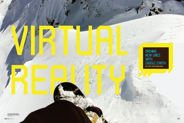
The spin in the booklets was steep, but what made this finger so sketch was a mix of massive overhanging cornice and hair-trigger stability that had plagued the C Coast Range for most of March. The big-line community was still on alert, so the fact that Pemberton local Joe Lax was roped into a backup anchor of a buried Jones splitboard, on belay from riding partner Dave Bassachetra and chopping an entrance with his avalanche shovel to nail this line at sunset was putting me on edge, even from a safe, side-angle vantage.
Four of us wer halfway up the Hurley at least two hours by sled from the trucks in a fresh new zone that this particular crew had been trying to crack into since photographer emeritus Chris Ankeny had discovered it on Google Earth from his Pemberton coffee shop. Pioneering new zones far above this former farm town had become a bit of an obsession, not only for these three locals, but also for a growing circle of post-pro transplants and big-mountain addicts, who had relocated their lives and ladies to be in daily contact with some of Canada’s sickest terrain and most secretive lines.
This particularly stacked zone, of north-facing, two-grand walls, was still a bit of a mystery. The fluted features may have been hit before by a Bralorne-based crew, but no one on either side was broadcasting their location. Either way, the spines were still fresh for us and this session was a personal triumph since it has been a three-year, on-and-off project to connect the dots and find the entrance,. Four days prior, the secret almost got snaked by a Matchstick film crew that cut loose one of the spines, then reloaded into their private heli for an airlift to more stable ground. FOr us, finding the front door was a terrestrial mission involving logging-road logistics, setting a steep virgin sled track through tight timber and in my case-with my limited side-hilling skills-a two-grand splitboard ascent up the long track to treeline where I linked back up with Ankeny’s Arctic Cat for a tandem shuttle to the back bowl of this Coast Range subsector. The entry was far from easy and far from obvious, but the real reason we were here, cracking this one open, was Google Earth.
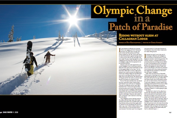
Arriving from Whistler or Washington, it’s tough to overstate how much terrain fans out from the single stoplight at Pemberton’s junction on the Highway 99. Mt Currie’s massive 8,501-foot face towers over town, its Y chute a big-line prize first tagged by ski legends Eric Pehota and the lat Trevor Peterson. To the dry east side, Duffey Lake Road provides elevated access to broad drainages and steep peaks with a handful if the AT traffic found on Canada’s skintrack superhighways. Coastal icecaps run cold to the west and, to the north, rich farmaland and vacation lakes rise into sled sectors that stack up for more than 60 clicks toward the grizzled, backwoods hamlet of Bralorne.
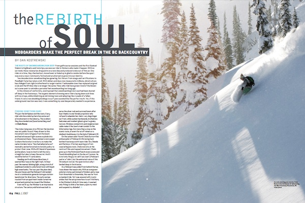
But these are only the known zones and even as the Pemberton mystique has grown with visiting film crews, publicized trip reports and an in-migration, a nucleus of seasoned locals have started to get a bit farther back using the holy trinity of sled skills, splitboard legs and Google Earth. Ankeny likes to say that with skins you can access five percent of the local terrain, but a sled and a splitboard open up a lifetime of lines. In this game, a fast MacBook is one tool, but local knowledge and local proximity are still major advantages.
I had no Pemberton residency, but one day earlier, one day late, I’d arrived to a home-cooked meal and a look of shell shock at the townhouse Ankeny shares with his fiancée Lisa Kormuro. The locals got out early but the shakedown day breaking trail hadn’t gone according to plan, with buried surface hoar resulting in spooky avalanche conditions. Dave Bassachetra and his wife Venessa Stark set off a sympathetic class-three fracture from flat ground; Ankeny popped and dropped a section into a scary terrain trap and natural slides on multiple aspects resulted in a full retreat from the backdoor of the Booklets.
In Pemberton’s tight-knit, big-line community word travels fast. Back at Ankeny House with pasta cooking on the stove, cold beers in the fridge and baby furniture in the living room, calls started coming in to confirm aggressive lines skied in zones out the Hurley and up the Duffey. Chris gets word that Travis Rice’s posse has parked their sled trailers behind his coffee shop, Jonaven Moore’s Deeper crew heli-dropped on an exposed shoulder in the Tantalus and a Matchstick film crew may have beat us to the Booklets.
The night I arrived the telephone tree had a different message. The local’s report was buzzing with daily summaries of touchy conditions and lucky escapes. Even the heli guides at TLH had seen their lowest-angle slopes sliding big and longtime locals were claiming the worst stability in four seasons. But the coastal snowpack healed quickly and the energy in town was now pumping for the bluebird swell.
“Sometimes the hardest thing on a good day around here is just deciding where to go,” Ankeny says as he clears the dishes. “You jsut want to clone yourself, there are so many good spots.”
Then he settles in for a Google Earth session to show me the stashes. With his seven-month-old son Kai testing out his lungs upstairs, Chris spins the Google Earth globe with a single click and zooms into his coffee shop across the street. As he pans back for perspective, hundreds of placemarks pop into view-each one representing a line, a zone or a mission in the vicinity.
I take the straight shot, cutting the entrance and then surfing high on the walls as the sluff peels away beneath my feet. Even with all the technical assistance, it has taken four days to get this line. But deep in the pocket, the exhaustion fades into an awesome silence. IN this moment, the feeling of pioneering a new line, in a new place, is so much of a rush that time seems to slow. An instant later, I hit the chundered flats to see Chris dropping one line left and negotiation some pepper to an exit in the fog, then I stare straight up and see Joe come steaming straight down from the burliest line.
I take my breather at the lake, while Joe and Chris go collect the Arctic Cat from the ridge. I know my legs are done, but not knowing when this window will be open again, I jump back on Joe’s Ski-Doo for a sketchy, skillful tandem-three at a time on a one sled through the alpine-to get a second does of X.
“That takes some big balls,” Chris says, hands in the pockets of his AK puffy, waiting to shoot Joe who is hanging it out there, chopping an entrance to his chosen spine.
As Dave feeds out rope, Joe leans out to its short limit and cuts the last chunks from a narrow slot that will allow him to slip onto the spine. It’s calm but tense and I break my silence with a quiet, “Definitely.”
By now, I am lost in my own thought, realizing that we never would have set eyes on this line without the visual instigator of Google Earth. Like maps that brought Euros across the oceans or surveys that punched through Canada’s mountain passes, knowing nirvana exists in powerful motivation to explore the other side. New technology is the foundation for an age of discovery and in this case, a source of transformation in the way I see my lines.
Staring down at the no-fall zone six days deep into the foreign experience, I’m nervous about making it back before dark and buzzing about being someplace so vast, so remote and so indelible. It was, of course, another good epic with a massive bowl sliding from the echoes of the two-strokes and my own virgin drop cautiously ridden right to left and exited through a rubbled choke. But we also cracked canned beer in the sun while appreciation first lines for all four of us on the pages of Booklets.
Even without the drama or the sunset, I can feel this chapter is the crescendo-the big conclusion to a big week burning energy, adrenaline and marked gasoline to open whole new sectors. But this mission was about more than just another fresh line-it was about finding solitude and adventure in places no one has ever really looked. It’s a discovery and a vision that will pull me back again.
I’m definitely spent from the experience and Chris pulls a snack from his pocket and offers me half for a refuel. “Espresso brownie from the shop,” he says. “It’s got powers.”
I take the sugar rush, calm my nerves and soak in a sunset that is illuminating a lifetime of potential. Joe drops in with calculated prevision and Dave rips his own exposed rib to the bottom. The face is a bit crooked and the riding is shot, so we gear up for the whooped two-hour exit by headlight to cold beer and dry shoes at the trucks. It’s over for now, but this area is one more door that is now open.
“I think we’ve got an hour until the girls start calling each other,” Dave says, reminding us it has been another long day as we swill cold Keith’s by headlamp at the tailgate.
For the hometown crew, this mission was just another breakthrough-part of an ongoing, eye-opening awareness of how much is now possible. Yet for me, access to this vast database of terrain will be limited to gawking, hour after hour, on Google Earth until I make it back to their reality again. Until then, the unknown will be here, tempting us all with the next unridden line.